


El comportamiento medio del clima de nuestra región se muestra a través de mapas de variables climatológicas como precipitación, temperatura e insolación, tanto a escala anual como mensual. En el caso de las variables anuales se representan también variables como el número de días de heladas, la torrencialidad de la lluvia y el índice de humedad.
La intervención de los factores del clima que acabamos de mencionar - particularmente la latitud subtropical y la abundancia de situaciones anticiclónicas sobre la región- determina la existencia en Andalucía de una insolación muy elevada (ver mapas mensuales). Todo el valle del Guadalquivir y los espacios costeros, con la excepción del área del estrecho de Gibraltar, supera las 2800 horas de sol al año, sobrepasándose incluso las 3000 horas en algunos enclaves del golfo de Cádiz y la costa almeriense. El resto de la región queda comprendido entre 2800 y 2600 horas de sol, escapando a esta norma sólo los lugares más elevados de los espacios serranos, en los cuales la mayor presencia de nubosidad por efecto del relieve, reduce la insolación por debajo de 2600 horas anuales. Estos altos valores de insolación, asociados al elevado ángulo de incidencia de los rayos solares en estas latitudes tan bajas, determinan también valores elevados de recepción de radiación solar, que superan los 5 Kw/h/m2.
Ambos elementos constituyen, sin duda, dos de los principales recursos que el clima exhibe en el territorio, pero ejercen además una incidencia clara en la configuración de las temperaturas en la región.
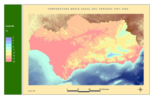
La temperatura media anual adopta valores muy diversos, que reflejan un gradiente costa-interior y, sobre todo, un fuerte gradiente altitudinal, de forma tal que los valores más bajos (inferiores a 9-10°) se encuentran en los enclaves montañosos del interior de las cadenas Béticas (Sierras de Cazorla y Segura, Sierra Nevada...). El flanco occidental de estas cadenas, más abierto a la influencia atemperante del Atlántico, y el conjunto de Sierra Morena, presentan valores más elevados, que oscilan entre 12° y 15°. En la costa atlántica se superan ya los 15°, y en el valle del Guadalquivir y algunos puntos de la costa mediterránea se pueden rebasar los 18°, alcanzándose incluso 20° en algunos enclaves del litoral almeriense, que se constituye en uno de los puntos más cálidos de España. (ver mapas mensuales)
El riesgo de heladas refleja en gran medida este comportamiento de las temperaturas y se muestra como un fenómeno relativamente infrecuente en la región. En ninguna de las áreas no montañosas se superan los 20 días anuales de helada y éstos llegan a ser un fenómeno rarísimo en las zonas costeras, sobre todo en la costa mediterránea, suavizada por el comportamiento térmico del mar interior y protegida de las advecciones de aire frío del norte por las cadenas Béticas. En realidad, sólo adquieren alguna relevancia en las zonas más elevadas, tales como Sierra Nevada y la Sierra de Cazorla, en las cuales se rebasan los 60 días de helada al año. Ello configura en la región un periodo libre de heladas muy prolongado, lo que permite el crecimiento vegetativo de las plantas sin apenas problemas. En la costa mediterránea el periodo libre de heladas supera los 350 días, lo que supone su casi total ausencia, y en todas las zonas costeras más las áreas relativamente llanas, especialmente en la parte occidental, el periodo supera los 250 días anuales. Así pues, sólo en los ámbitos septentrional y oriental de la región, sobre todo en sus enclaves más elevados, se constituyen periodos libres de heladas lo suficientemente cortos como para suponer alguna limitación al desarrollo de la agricultura. También son infrecuentes las olas de frío generalizadas, aunque pueden suceder con ocasión de invasiones de aire polar por advecciones del norte y nordeste, en cuyo caso toda Andalucía, con muy escasas excepciones, puede llegar a soportar temperaturas negativas, alcanzándose valores de 20 y 25° bajo cero en los altiplanos orientales y en la alta montaña (ver tabla 1).
En cuanto a los totales pluviométricos anuales pueden establecerse en Andalucía cuatro grandes dominios (ver figura 1):
El comportamiento de las precipitaciones de especial intensidad es reflejado por los valores de precipitación máxima en 24 horas para un periodo de retorno de 100 años y por el índice de torrencialidad de la lluvia, que constituyen respectivamente valores absolutos y relativos. La precipitación máxima para un periodo de retorno de 100 años es expresiva de la lluvia diaria máxima que es esperable por término medio una vez cada 100 años, siendo por tanto su probabilidad de ocurrencia muy reducida, de sólo un 1%. En el escenario andaluz la isolínea 150 mms. individualiza los ámbitos en los que estas precipitaciones son realmente muy intensas de aquellos otros en los que la lluvia no presenta comportamientos paroxísmicos reseñables. Entre los primeros cabe situar las estribaciones occidentales de Sierra Morena y la mayor parte de las Cadenas Béticas, pudiendo establecerse en ellas cuatro dominios: el dominio más occidental, correspondiente a las provincias de Cádiz y Málaga, un núcleo central, situado en la provincia de Granada, el sureste almeriense y un pequeño ámbito sobre las sierras de Cazorla y Segura.
El índice de humedad resulta del cociente entre la precipitación anual media, expresiva del aporte de agua en la región, y la evapotranspiración potencial media anual, que reflejaría la demanda de agua ejercida por el medio, y que estaría determinada básicamente por la temperatura. Los tonos más pardos representan los valores del índice inferiores a la unidad, es decir, aquellos en los que P es inferior a ETP, y ocupan la mayor parte del territorio andaluz. Destaca en su interior el sudeste almeriense, donde la aridez es máxima, al existir índices de humedad inferiores a 0,3. Hay que reseñar, no obstante, que la existencia en todo este ámbito de valores de P inferiores a los de ETP no impide que se produzcan excedentes en algunos meses del año, siendo estos excedentes los que alimentan la escorrentía. Éstos pueden existir en cualquiera de los ámbitos de la región (salvo algunos enclaves del sureste almeriense) por el efecto de la concentración de la precipitación en la estación invernal y, de hecho, incluso en el área más árida de Andalucía se contabilizan hasta tres meses en los que la precipitación supera a la evapotranspiración potencial.
Las tonalidades con verdes más intensos del mapa corresponden a los lugares en los que el índice de humedad supera el valor de 1, e individualizan siempre los lugares de montaña, que ya se habían distinguido por sus elevados valores de precipitación y por sus temperaturas bajas. En algunos ámbitos, como Aracena, Cazorla y, sobre todo, Grazalema, el índice de humedad supera el valor de 1,5 y en todos ellos los excedentes de precipitación son muy cuantiosos, constituyéndose en verdaderas fuentes de recursos hídricos para la región. A pesar de ello, también en estos lugares se registran déficit de agua en la estación estival y en todos existen cuatro meses en los que la ETP supera a la P, lo que de nuevo pone de manifiesto el carácter absolutamente definitorio de la sequía estival en el clima andaluz.
La intervención de los factores del clima que acabamos de mencionar - particularmente la latitud subtropical y la abundancia de situaciones anticiclónicas sobre la región- determina la existencia en Andalucía de una insolación muy elevada. Todo el valle del Guadalquivir y los espacios costeros, con la excepción del área del estrecho de Gibraltar, supera las 2800 horas de sol al año, sobrepasándose incluso las 3000 horas en algunos enclaves del golfo de Cádiz y la costa almeriense. El resto de la región queda comprendido entre 2800 y 2600 horas de sol, escapando a esta norma sólo los lugares más elevados de los espacios serranos, en los cuales la mayor presencia de nubosidad por efecto del relieve, reduce la insolación por debajo de 2600 horas anuales. Estos altos valores de insolación, asociados al elevado ángulo de incidencia de los rayos solares en estas latitudes tan bajas, determinan también valores elevados de recepción de radiación solar, que superan los 5 Kw/h/m2.
Andalucía presenta una gran diversidad en los totales pluviométricos es compatible, sin embargo, con la existencia de un régimen de precipitaciones que muestra rasgos comunes para toda la región. El primero de estos rasgos es el intenso déficit hídrico estival, que afecta prácticamente por igual a todo el territorio, de forma tal que en ningún caso las precipitaciones estivales alcanzan el 6% de las anuales, siendo su porcentaje normalmente inferior al 3%. Es también una nota dominante en la región el predominio de las precipitaciones invernales frente a las del otoño o la primavera, como consecuencia de la presencia frecuente entonces de vaguadas en la corriente en chorro y del vigor que alcanzan las perturbaciones del frente polar. Las estaciones equinocciales presentan un comportamiento más variado y, con arreglo a este criterio, pueden establecerse dos grandes conjuntos: el ámbito interior, en el cual el trimestre más lluvioso del año es el comprendido por los meses de enero, febrero y marzo, marcándose así la importancia de la primavera como segunda estación más lluviosa del año después del invierno, y el ámbito que podríamos denominar periférico, en el cual el otoño ocupa un papel más relevante, siendo el trimestre más lluvioso del año el constituido por los meses de noviembre, diciembre y enero. Dentro de este segundo conjunto cabe distinguir, además, el ámbito mediterráneo, en el cual el peso del otoño es particularmente relevante. En él las precipitaciones otoñales totalizan aproximadamente el 30% del total anual, en tanto que en el dominio atlántico es el invierno el que predomina con claridad al totalizar más del 40% de las lluvias anuales.
En esta serie, merece la pena el comentario de los mapas de temperatura de los meses de Enero y Julio, expresivos de las condiciones invernales y estivales respectivamente. El mapa de la temperatura media de enero (ver figura 2) dibuja con más claridad aún que el caso anterior los gradientes altitudinales y costa-interior, que son los verdaderos artífices de la temperatura de la región. Los valores más reducidos aparecen siempre en los lugares más elevados, interiores y orientales de la región. Así, todo el conjunto integrado por las Béticas orientales queda por debajo de los 6° de temperatura, destacándose en su interior los lugares más elevados, en los cuales la temperatura suele descender de los 3° e incluso en algunos puntos puede adoptar valores bajo cero. Por el contrario, la porción más próxima al Atlántico del valle del Guadalquivir y los ámbitos costeros registran temperaturas superiores siempre a 9°-10° y a veces, a los 12°.
Durante el verano estas áreas de montaña siguen presentando las temperaturas más bajas (inferiores a 18° en algunos casos), pero ahora las máximas no se encuentran en las zonas costeras, sino en el interior de la región, que no puede beneficiarse de la influencia suavizadora del mar. Todo el interior del valle del Guadalquivir presenta temperaturas medias de julio superiores a 26°, que en algunos reductos llegan a superar los 28°. La elevada magnitud de estos valores - los más altos de España - se comprende adecuadamente si se tiene en cuenta que resultan de la media de temperaturas diurnas y nocturnas. Dado que durante el verano la nubosidad es prácticamente inexistente en la región y la insolación es muy acusada, la amplitud térmica diurna resulta muy elevada, lo que implica que estos valores medios son el resultado de temperaturas diurnas que normalmente superan los 35°. Con ocasión de las invasiones de aire sahariano asociadas a crestas anticiclónicas cálidas en altura , las máximas se sitúan por encima de 40° en la mayor parte de Andalucía y pueden rebasar los 45° en las tierras bajas del interior del valle del Guadalquivir.
El comportamiento medio del clima de nuestra región se muestra a través de mapas de variables climatológicas como precipitación, temperatura e insolación, tanto a escala anual como mensual. En el caso de las variables anuales se representan también variables como el número de días de heladas, la torrencialidad de la lluvia y el índice de humedad.
The intervention of the climate factors that we've just mentioned - particularly the subtropical latitude and the abundance of anticyclonic situations on the region - determines the existence in Andalusia of a high insolation level (see months maps). All the valley of the Guadalquivir and the coastal spaces, except for the area of the Strait of Gibraltar, are over 2800 sunny hours per year, reaching more than 3000 hours in some locations of the Cadiz Gulf and the coast of Almeria. The rest of the region has between 2600 and 2800 sunshine hours, scaping from these values only the highest areas of mountainous zones, on which the pressence of cloudiness due to the relief, reduces the insolation under 2600 hours per year. These high insolation values, associated to the high incidence angle of solar rays in these low latitudes, also determine high values of solar radiation reception, over 5Kw/h/m2.
Both elements constitute, with no doubt, two of the principal resources that the climate has in the territory, but they have although a clear incidence in the configuration of the region's temperatures.
The annual average temperature adopt varied values that reflect a coast-interior gradient and, over all, a strong altitudinal gradient, making the lower values (less than 9-10°) appear in the mountainous areas of inside the Betic range ( Cazorla y Segura, Sierra Nevada...). The occidental face of these mountain ranges, more openned to the influence of the softening Atlantic, and the conjunction of Sierra Morena, present higher values, variating between 12° and 15°. In the Atlantic coast 15° are passed and in the Valley of the Guadalquivir and some point of the mediterranean coast 18° can be passed, reaching even 20° in some places in Almeria, which is one of the warmest places of Spain. (see months maps)
The risk of frosts reflects this behaviour of temperatures and it's a less frequent phenomenon in the region. In non of the non mountainous areas of the region the annual days of frost are over 20, and they're a really strange phenomenon in coastal zones, specially in the mediterranean coast, softened by the thermical behaviour of the inside sea and protected of the cold air masses advections from the North by the Betic ranges. The truth is that this phenomenon is only relevant in the highest areas, like Sierra Nevada or Cazorla, where there are more than 60 annual frost days. That configures a long period free of frosts in the region, allowing the vegetative growth of the plants without problems. In the mediterranean coast, the free of frost period is over 350 days, what means that there's nearly a total abscence of frosts, and in all the coastal areas plus the relatively flat areas, specially in the occidental part, the period is over 250 days. So, only in the North and West of the region, over all in the highest places, free of frost periods short enough to become a restriction for agriculture take place. Also, there aren't frequent generalized cold spells, but they can happen due to polar air invasions through advections from the north and north-east. When that happens, Andalusia, with very few exceptions, can be at negative temperatures, reaching values of 20° or 25° under cero at the oriental high plateaus and at the highest mountains (see table I).
In conjunction and on what reffers to annual pluviometric totals, four big domains can be established in Andalusia (see the map of average annual rainfalls):
The behaviour of rainfalls with special intensity is reflected by the values of maximum rainfalls in 24 hours in a return period of 100 years and by the torrentiality index of rainfalls, constituting respectively the absolute and relative values. The maximum rainfall in a 100 years period expresses the predictable daily maximum rainfall in average once every 100 years, being so its probability very reduced, of only 1%. In the Andalusian scenary the isoline 150mms. separates the areas where these rainfalls are really very intense from those areas where rainfalls don't have noticeable paroxísmic behaviours. Among the first ones we can situate the occidental foothills of Sierra Morena and the major part of the Betic ranges, where we can establish four domains: the most occidental domain, corresponding to Cadiz and Malaga, the central nucleus, located in Granada, the south-east of Almeria and a small area over the mountain ranges of Cazorla and Segura.
The humidity index results from the division between the annual average rainfall, expressive of the water contribution in the region, and the annual average potential evapotranspiration, which reflects the water demand exerted by the environment, determined basically by temperature. Brown colours represent index values under the unity, i.e., those where P is under ETP, and they occupy the majority of Andalusian territory. The South-East of Almeria stands out inside it, where the aridity is maximum, because there are humidity indexes under 0'3. We have to say anyway, that the existence in this area of P values under ETP doesn't impede the pressence, some months, of excesses, being these excesses who feed the "escorrentía" . They can exist anywhere in the region (except in some places in Almeria's South-East), due to the effect of the rainfall concentration in winter and, in fact, even in the dryest area of the region, there are up to three months where the rainfall is over the potential evapotranspiration.
Green colours correspond to places where the value of the humidity index is over 1, and they always individualize mountainous places, because they have been distinguished due to the high values of rainfall and to their low temperatures. In some areas, like Aracena, Cazorla and, over all, Grazalema,the humidity index is over 1'5 and in all them, the rainfall excesses are quite substantial, becoming real hydric sources for the region. Instead of that, also in these places, water deficit is registered in summer and there are four months when ETP is over P in all these places, what again shows the determining character of summer drought in the Andalusian climate.
The intervention of the climate factors that we've just mentioned - particularly the subtropical latitude and the abundance of anticyclonic situations on the region - determines the existence in Andalusia of a high insolation level. All the valley of the Guadalquivir and the coastal spaces, except for the area of the Strait of Gibraltar, are over 2800 sunny hours per year, reaching more than 3000 hours in some locations of the Cadiz Gulf and the coast of Almeria. The rest of the region has between 2600 and 2800 sunshine hours, scaping from these values only the highest areas of mountainous zones, on which the pressence of cloudiness due to the relief, reduces the insolation under 2600 hours per year. These high insolation values, associated to the high incidence angle of solar rays in these low latitudes, also determine high values of solar radiation reception, over 5Kw/h/m2.
Andalusia presents a big diversity in pluviometrical totals is compatible, anyway, with the existence of a rainfall regime having common features for the whole region. The first one of these features is the summer intense hydric deficit, that affects all the territory in the same way, meaning that summer rainfalls never reach the 6% of the total annual rainfalls, being that percentage normally under 3%. It's also a dominant feature in the region the predominance of winter rainfalls instead of spring or autumn, as a consequence of the frequent pressence of watercourses around the jet stream and the energy that the polar fronts reach. The equinoxial seasons present a more varied behaviour, and, using this criterion , two big groups can be established: the interior field, where the rainiest quarter of the year is formed by January, February and March, showing the importance of spring as the second rainiest season of the year after winter, and the so-called peripheric field, where autumn plays the most relevant role, being the rainiest quarter of the year the one formed by November, December and January. Inside this second field we have to distinguish, also, the mediterranean area, where the role that autumn plays is particularly relevant. In it, autumns rainfalls constitute approximately the 30% of annual rainfalls, while in the atlantic domain winter is clearly the predominant having the 40% of total annual rainfalls.
These abstract values, resulting from the joint consideration of varied situations during the whole year, get more concrete considering the temperatures maps of January and July, expressive of winter and summer conditions respectively. The January's average value map (see figure 2) draws more clearly than the previous case the altitudinal and coast-interior gradients, which are the real authors of the temperature of the region. The lowest values appear always in the highest interior and oriental locations of the region. In that way, all the oriental Betics are under 6°, standing out inside them the highest places, where the temperature can go under 3° or even values under 0° in some places. In the opposite, the nearest to the Atlantic portion of the Valley of the Guadalquivir and the coastal areas register temperatures always over 9°-10° and, sometimes, over 12°.
During summer these mountainous arear continue having lower temperatures (under 18° in some cases), but now, the maximum temperatures are not at coastal zones, but in the inside part of the region, where the softening effect of the sea has no influence. The whole interior part of the valley of the Guadalquivir presents average temperatures in July over 26°, rising above 28° in some places. The high magnitude of these values - the highest in Spain- is understood right if we take into account that they're the result of the average day an night temperatures. Because the cloudiness during summer is nearly non-existent in the region and the insolation is very pronounced, the daily thermical amplitude results very high, what implies that these average values are the result of daily temperatures that normally rise above 35°. When saharian air masses invasions associated with warm in altitude anticyclonic crests take place, the maximum temperatures rise above 40° in the major part of Andalusia and can reach 45° at the low territories of inside the valley of the Guadalquivir.

