The Life Agromitiga project aims to contribute to the transition towards a low-carbon agricultural system by providing validated results that can be applied to the EU's commitments within global climate alliances.
The main objectives of the project are:
- To improve the understanding of soil carbon content.
- To design and implement a carbon footprint calculation methodology for the agronomic phase of crops, which can be integrated into international standards for carbon footprint verification and calculation.
- To develop a technological tool that allows for the evaluation and quantification of carbon increases due to improved soil practices, which can serve as a basis for the development and monitoring of policies related to climate change and emissions trading.
- To demonstrate the greenhouse gas emissions reduction potential of Conservation Agriculture in the Mediterranean Basin.
- To demonstrate the greenhouse gas emissions reduction potential of Conservation Agriculture in the Mediterranean Basin.
- To disseminate and transfer the acquired experience and soil management philosophy to similar regions of the Mediterranean.
- Coordinating Partner: Spanish Association of Conservation Agriculture, Living Soils.
- Beneficiary Partners: ASAJA Sevilla, ECAF (European Conservation Agriculture Federation), Ministry of Sustainability, Environment and Blue Economy (CSMAEA), IFAPA (Institute of Agricultural and Fisheries Research and Training), University of Córdoba.
The LIFE Agromitiga project includes a total of 24 actions to be carried out over a period of four years. These actions involve technical tasks aimed at implementing Conservation Agriculture techniques for carbon sequestration and their integration into a carbon footprint quantification methodology. The project also includes the development of a mobile app to evaluate soil carbon content in agricultural fields. In addition, governance and outreach actions are planned, including events such as workshops, training courses, and conferences.
During this phase, the Conservation Agriculture practices to be tested were identified, both for herbaceous and woody crops, in order to assess their potential to mitigate climate change. In addition, the region was divided into zones where the demonstration farms would be implemented, with the aim of identifying the soil’s carbon sequestration potential. Once the zoning was completed, 35 farms were selected in Andalusia and in three Mediterranean countries where implementation actions were carried out.
During this phase, Conservation Agriculture practices were implemented, and monitoring of soil carbon content and greenhouse gas emissions was carried out across the established network of farms, assessing gains compared to conventional management systems. In addition, an app was developed that uses mobile phone camera images to calculate carbon content in agricultural soils. A Governance Plan was also established to facilitate the participation and involvement of stakeholders in the project.
In parallel with the development phase, communication and dissemination actions were carried out to give visibility to the project and its results, including meetings with various stakeholders and with policymakers in the agricultural and environmental sectors at regional, national, and European levels.
- Project Start Date: September 1, 2018
- Project End Date: February 29, 2024
Although two actions have been carried out, both are closely related, with the first constituting the initial phase of the second.

In this action, a territorial analysis was carried out, which, considering the main factors that can influence organic carbon content in the soil (SOC), served as the basis for selecting locations to establish the farms where mitigation practices would be implemented, representing the predominant productive environments of agricultural land use in the region.
Similarly, the zoning was established as the foundation for distributing the sampling plots in which the specific organic carbon (OC) content was determined, used in activity D2.

Organic carbon in the soil, as an integral part of organic matter, plays an important role. Its content contributes to improving the stability of soil aggregates, increasing porosity and the circulation of air and water, enhancing water retention capacity and fertility due to its high adsorption and ion exchange capacity.
Its content is dynamic, largely conditioned by its management and usage, with soil potentially acting as a carbon sink, thus contributing to the mitigation of greenhouse gases associated with climate change.
On the other hand, a decrease in its content not only worsens its physico-chemical properties but also contributes to climate change by generating CO2 from microbial metabolism during decomposition.
Understanding SOC levels is a complex task, as its high spatial variability makes direct observation in large areas difficult due to its high economic and, above all, time cost.
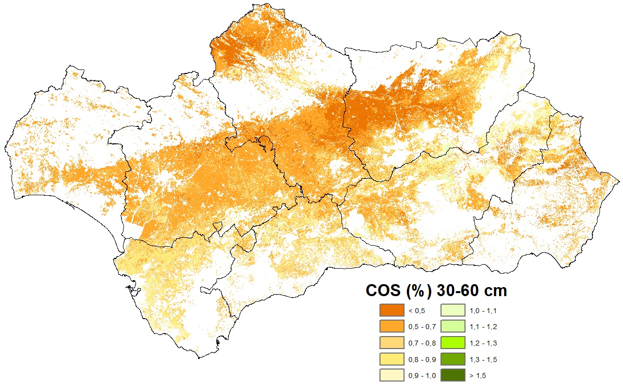
To overcome this issue, sampling was carried out at 684 significant points in the agricultural areas of the region. Combined with the aid of new digital mapping technologies, this allowed us to correlate organic carbon content from these direct observations with various environmental variables determined at the same locations, in order to develop predictive models and extend SOC content information to other areas of the region.
The use of these innovative techniques has enabled us to produce two maps of average CO content (%) at two depths: 0-30 cm and 60-30 cm, complemented by two additional maps, one for each depth, showing the degree of uncertainty (expressed in the same units as the content) of the selected predictive models.
These results are useful for obtaining a regional view of SOC levels, particularly for establishing behavior patterns at a regional scale, feeding evaluation models, or running behavior simulations. They are not valid for local scale use, as the high spatial variability of SOC content would have required an unfeasible number of samples within the timeframe of this project.


