Andalusia 2013
Environmental Management
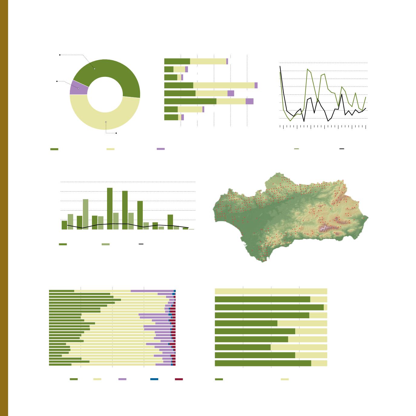
Location of sample plots of SEDA network*
Campaign 2012
* SEDA:
Andalusian network for
Damage Monitoring in Forest Ecosystems
Almeria
Cadiz
Cordoba
Granada
Huelva
Jaen
Malaga
Seville
192,394
Total Extension in Andalusia:
1,262,853 ha
71,510
56,882
210,942
120,829
59,155
0
50 100 150 200 250 *
100 %
Regional Administration
Local Administration
Other public entities
Broad-leaved trees
Coniferous tree
* Surface (ha)
Unidad %
2012
2008
2004
2000
1996
1992
1998
281,727
269,414
40
30
20
10
0
48.2
Local Administration
6.9
Other
public
entities
44.9
Regional
Administration
Ownership of the Public Forests of Andalusia 2011
Percentage of trees damaged
by plagues by groups of species
in sampled plots
[8]
Attack index
Affected surface
number of outbreaks
2004 2005 2006 2007 2008 2009 2010 2011 2012
Evolution of surface afected by pine shoot beetles,
attack index and number of outbreaks
* Surface (ha) ** Attack index (ha)
Attack index represents the surface of dead trees directly caused by pine shoot beetles
3,000
4,000
5,000 *
2,000
1,000
0
300
400
500 **
200
100
0
Defoliation:
1987
1988
1989
1990
1991
1992
1993
1994
1995
1996
1997
1998
1999
2000
2001
2002
2003
2004
2005
2006
2007
2008
2009
2010
2011
2012
0
25
50
75
100 %
Evolution of the phytosanitary condition of forests
[8]
0
None
1
Slight
2
Moderate
3
Severe
4
Dry tree
Apiculture (nº beehive)
Cork (kg)
Fruit (kg)
Firewood (kg)
Biomass (kg)
Wood (m
3
)
Scrub (kg)
Manure (kg)
Pasture (bovine heads)
Mushrooms (Kg)
0
25
50
75
100 %
170,395
4,150,171
740,975
2,191,715
711,050
13,201,317
2,504,083
87,750
69,991
264,237
104,944
2,099,675
1,120,479
33,000
33,500
47,680
19,102
99,175
16,500
Public Forest Exploitations in Andalusia, 2012
Production in protected areas
Production in non protected areas
Forest
18


