60° E
50° E
40° E
30° E
30° E
20° E
20° E
10° E
10° E
0°
0°
-10° W
-20° W
-30° W
60° N
60° N
50° N
50° N
40° N
40° N
Madeira(PT)
Canaries(ES)
Guadeloupe(FR)
Martinique(FR)
FrenchGuiana(FR)
Reunion(FR)
Azores (PT)
Madeira (PT)
Canaries (ES)
Gu deloupe (FR)
Martinique (FR)
French Guiana (FR)
R union (FR)
Mayotte (FR)
Malta
North-
umbria
Solway
Tweed
Scotland
Humber
N
o
r
t
h
W
e
s
t
Anglian
Thames
Sout
h
E
a
s
t
South West
Dee
Western
Wales Severn
South
Western
South
Eastern
Western
Eastern
Sha
n
n
o
n
Neagh
Bann
UK
IE
IE
CELTIC SEA
English Channel
IRISH SEA
NORTH SEA
North
Western
ES
Loire
Adour-Garonne
Minho
Ebro
Douro
Canta
b
rico Occiden
t
al
Galician
Coast
ES
ES
ES
ES
PT
PT
PT
PT
Ta g u s
G u a d i a n a
Vouga, Mondego,
Lis and West Rivers
Sado
and
Mira
Cavado,
Ave and
Leca
Algarve
Basins
Cantabrico
Oriental
Guadalquivir
Tinto,
Odiel
and
Piedras
Andalusia
Mediterranean Basins
Guadalete
and
Barbate
Segura
Jucar
Internal
Basins of
Catalonia
Bale
a
ric
I
sland
s
North
Eastern
Sardinia
Middle
Appenines
Sicily
Serchio
Northern
Appenines
Corsica
ES
FR
FR
Po
Basin
IT
CH
R
h
o
n
e
CH
Northern
Appenines
Southern
Appenines
EL
East
Aegean
Crete
Eastern
Peloponnese
Western
Peloponnese
Northern
Peloponnese
Western
Sterea
Ellada
E
pi
r
us
Western
Macedonia
Central Macedonia
West
Aegea
n
EL
EL
EL
EL
AL
MK
Thessalia
Aegean
I
slands
TR
BG
BG
RS
AL
Black
Sea
RO
HU
BG
UA
MD
MD
UA
UA
UA
ME
BA
HR
SI
SI
IT
CH
CH
AT
DE
AT
DE
R h i n e
FR
FR
FR
DE
BE
Meu
s
e
NL
S
c
h
e
l
d
t
NL
BE
FR
D
a
n
u
b
e
NL
NL
DE
Ems
Weser
Warnow/
Peene
E l b e
DE
CZ
Eider
Schlei/Trave
Jutland
and
Funen Zealand
DE
DE
Vidaa-Krusaa
DK
Bornholm
O d e r
V i s t u l a
DE
CZ
CZ
SK
SK
PL
D
n
i
e
s
t e r
PL
PL
Pregolya
PL
RU
BY
BY
Jarft
Swieza
Ucker
PL
PL
RU
Lielupe
LT
LT LT
LV
LV
LV
LV
Venta
LT
EE
Gauja
D
a
u
g
a
v
a
BY
N e m u n a s
RU
Ea
s
t
E
sto
n
ia
RU
EE
West
Estonia
Kymijoki-
Gulf of Finland
V u o k s i
FI
RU
Kokemaenjoki-
Bothnian Sea
Archipelago Sea-
Oulujoki
FI
Ke mijoki
FI
RU
Teno,
Naatamojoki,
Paatsjoki
FI
RU
F
innm
a
rk
NO NO
T
roms
Nordl
a
nd
NO
T
ornionj
o
ki
Torne
River
Bothnian Bay
FI
FI
SE
Bothnian
Sea
SE
NO
Troe
n
delag
NO
Moere
and
Romsdal
Sogn
and
Fjordane
Rogaland
Hordaland
Agder
West
Bay
North
Baltic
South
Baltic
Glomma
NO
NO
Skagerrak
and Kattegat
Aland
Islands
SE
BALTIC
SEA
Gulf
of Fi
n
lan
d
G u l f
o f
B
o t h
n
i a
Kattegat
Skagerrak
NORWEGIAN
SEA
Bay of
Biscay
M
E
D
I
T
E
R
R
A
N
E
A
N
S
E
A
Tyrrhenian Sea
Adriatic Sea
Eastern
Sterea
Ellada
Aegean Sea
BL ACK
SEA
Mediterranean Sea
Mozambique
Channel
Indian
Ocean
Atlantic
Ocean
Caribbean
Sea
Caribbean
Sea
Guadeloupe Passage
Atlantic
Ocean
Atlantic Ocean
Atlantic Ocean
PL
Attica
AD
UK
IE
IE
A
T
L
A
N
T
I
C
O
C
E
A
N
0 100
km
0 100
km
0 100
km
0 10
km
0 100
km
0 20
km
0 10
km
0 10
km
WHITE
SEA
S
e
i
n
e
Sambre
FR
Cueta
Melilla
0 100
km
1
2 3
4 5
6
7
Thrace
0 100 200 300 400
km
Eastern
Macedonia
C
y
p
r
u
s
Malta
1. La Palma
2. El Hierro
3. La Gomera
4. Tenerife
5. Gran Canaria
6. Fuertaventura
7. Lanzarote
Adriatic
Eastern
Alps
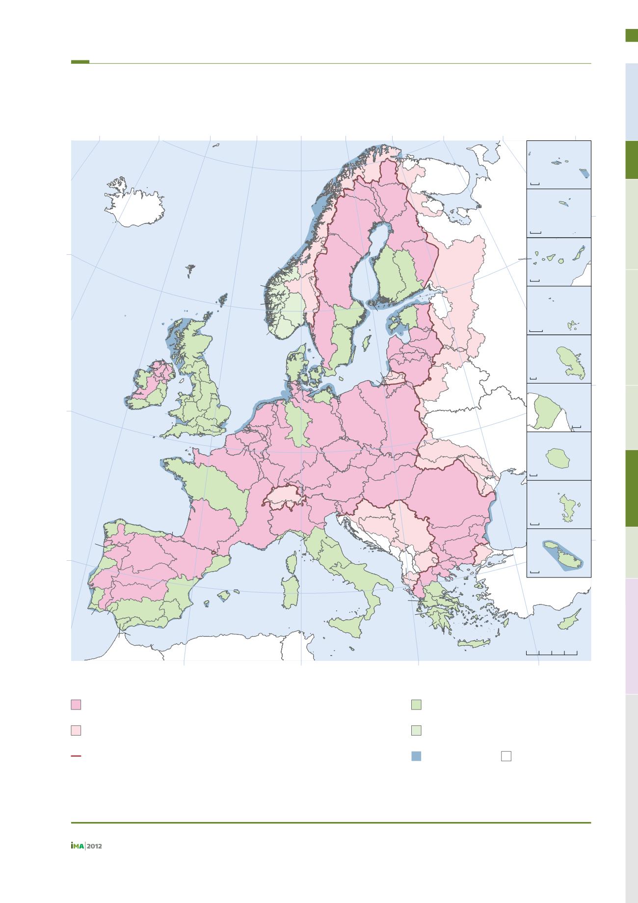
International River Basin Districts
Compiled from data reported to WISE by EU Member States
Approximate extent of International River Basin Districts outside of the EU
Compiled from data reported to WISE by AD, CH, LI MC and NO, supplemented with CCM2 Seaoutlets and ICPDR data
National River Basin Districts
Compiled from data reported to WISE by EU Member States
National River Basin Districts outside of the EU
Compiled from data reported to WISE by NO
Coastal waters
Country borders
National and International River Basin Districts
EU27 extent
Map produced by WRc plc on behalf of the European Commission ©, DG Environment, 2012.
Fuente:
Comisión Europea, 2013.
Demarcaciones hidrográficas nacionales e internacionales
versión 29 octubre 2012
291


